

- Special Offers
- Transceiver Radio
- Walkie-Talkies
- CB Radios
- Two-Way Transceiver Radio
- Two-Way Radio Repeater
- ATEX Intrinsically Safe Radio
- POC Radios
- Amateur Radio
- Communication Receiver
- Aviation Radio
- Marine Radio
- Icom Handheld Marine Radio
- Icom Mobile Marine Radio
- Midland Handheld Marine Radio
- Periskal Nautical Chart
- Satellite Marine Compass System
- AIS Transponder
- Marine Radar
- Satellite Phone
- WiFi Two-Way Radio
- TourGuide System
- Data Transceiver
- Transceiver Accessory
- Antennas
- Antenna Accessory
- Fiber Optics
- Cable
- Connector
- Installation Material
- Installation Tools
- Measuring Equipement
- Body Worn Camera
- Electrosmog
- Telephone
- Baby Monitor
- Fever Thermometer
- Radio Device
- Set-top Boxes
- Personal Protective Equipment
- Motorcycle Helmet Speaker
- Car Equipment
- Voltage Converter
- Dry Cell
- Battery
- Battery Charger
- Emergency Signal
- Amber Signal
- Sound Signal
- Light and Sound Signal Accessory
- Traffic Engineering
- LED Lamp
- Smart Home
- Mosquito Repellent Device
- Market - Other Products
- Discontinued Products
Pre-order (1)
Satellite Marine Compass System
A satellite marine navigation system can be used to generate and transmit vessel heading and positioning data. The satellite compass available in this category combines GNSS-based operation, optional support for multiple satellite systems, built-in gyroscopic compensation and standard NMEA0183 data connections. Heading and position data can be transmitted to radar, ARPA, ECDIS, AIS, chartplotter, autopilot, sonar and other marine navigation equipment. Read more...
Pre-order (1)
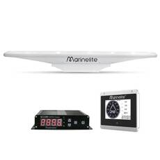
• Satellite compass system with 0.4° RMS heading accuracy
• Optional Beidou, GPS, GLONASS and Galileo support
• Built-in gyro compensation system
• Heading update rate up to 50 times per second
• Turning rate up to 90°/s
• 11-35 V power supply
• 6 NMEA0183 ports and AD-10 interface
• Package includes SC901 antenna unit, SC900 junction box, antenna data cable, 2-pin power cable, 8-pin data cable, optional 6-pin data cable, mounting bracket, installation manual and installation accessories

Satellite marine navigation system: heading and position data for marine navigation
The system operates with a 60 cm baseline length and 0.4 degree RMS heading accuracy, while pitch and roll accuracy are also 0.4 degree RMS. Position accuracy is 2.5 m, and GPS+BDS speed measurement accuracy is 0.1 m/s. During a cold start, time to first position is up to 32 s, during a warm start up to 1 s, while signal reacquisition takes up to 1 s. Heading update rate can reach 50 updates per second, and the supported rate of turn is up to 90 degrees/s.
How does the GNSS receiver work in marine navigation?
The satellite compass uses front-loaded carrier phase decoding technology to determine heading. In addition to speed and heading filtering functions, a built-in gyroscopic compensation system is also available. If GNSS-based heading determination is temporarily interrupted, the built-in inertial navigation module can provide compensation data. Compensation time can be set between 1 and 5 minutes.
GPS, BeiDou, GLONASS and Galileo satellite navigation
The multi-constellation configuration optionally supports BeiDou, GPS, GLONASS and Galileo. The GNSS system provides heading and positioning data that can be transmitted to additional marine navigation equipment through standard outputs. Supported NMEA0183 sentences include RMC, VTG, GGA, GSA, GSV, GLL, ZDA, HDT, ROT and THS.
What data do the NMEA0183 and GNSS interfaces transmit?
The system has six NMEA0183 data interfaces. Two GNSS outputs operate at 9600 bps, the data rate of two HDT outputs is adjustable, while two additional outputs can be used to transmit HDT and GNSS data. Two AD-10 interfaces, one display interface, one alarm input and an optional CAN interface are also included in the system design. The GNSS output transmits RMC, GGA, VTG, GLL and ZDA sentences at 1 Hz.
- HDT output frequency: 0, 1, 5, 10, 20 or 50 Hz.
- Adjustable serial data rates: 4800, 9600, 19200, 38400, 57600 and 115200 bps.
- The AD-10 data cycle is 25 ms.
- The CAN interface is optional and supports specified sentences.
When a larger number of output sentences or higher output frequencies are used, an appropriate data rate must be selected; otherwise, some sentences may be lost.
Marine antenna and connection to other navigation systems
The NMEA0183 outputs can provide heading and position data to radar, ARPA, ECDIS, AIS, chartplotter, autopilot and sonar systems. The system can also be connected to compatible equipment through an AD-10 connection. The optional display is a 5-inch unit with 800 x 480 resolution and offers Compass and Nav data display modes. Heading data, time and installation angle correction values can also be displayed.
How can heading data be used with radar, AIS, ECDIS and autopilot systems?
Vessel heading and position data can be transmitted to the listed navigation devices through standard NMEA0183 outputs. HDT, RMC and ROT sentences can be assigned to the HDT output, while output frequency and data rate can be adjusted according to the available settings. The default sentence ID associated with GNSS is GP, and GP, GB, GL or GN identifiers can be selected.
Positioning, heading updates and gyroscopic compensation
The user interface provides separate status indications for heading lock and position determination. If heading or position information is not available within two minutes, the corresponding indicator shows an alarm condition. Heading filter, speed and course filter, and rate of turning filter can be configured in the menu. Installation angle offset correction can also be set between -180.0 and 180.0 degrees, together with heading loss, positioning loss and over-voltage alarms.
What should be considered when installing the satellite navigation antenna?
The antenna should be installed at a high point on the vessel so that there are no obstacles in front of the satellite signal reception area. The equipment must be kept away from metal or magnetic surfaces that may reflect satellite signals; there must be no metal surface within a 2 m radius around the antenna above the horizontal plane of the device. Sufficient distance must also be maintained from radio-frequency radiation sources, and in the case of radar, the antenna must be installed outside the radar beam.
During installation, the longitudinal axis of the antenna must be aligned with, or positioned parallel to, the longitudinal axis of the vessel. Installation offset can be corrected between -180 and 180 degrees. Both pole and platform mounting are documented. The cable must not be excessively tight so that thermal expansion and contraction do not place mechanical stress on the cable or the equipment.
Advantages:
- Optional support for multiple GNSS satellite systems.
- Up to 50 heading updates per second.
- NMEA0183, AD-10 and optional CAN connections.
- Data can be transmitted to radar, ARPA, ECDIS, AIS, chartplotter, autopilot and sonar systems.
- The system operates without mechanical components and is maintenance-free.
Limitations and installation requirements: multi-constellation operation and CAN connectivity are optional. The installation location of the satellite antenna must be selected according to signal reception, multipath effects and radio-frequency interference requirements. The display unit is also optional.
Summary: satellite navigation in marine systems
A satellite marine navigation system provides heading and position data and can transmit this information to various marine instruments. The solution available in this category offers GNSS-based heading determination, gyroscopic compensation, configurable filtering, NMEA0183 and AD-10 interfaces, as well as optional display and CAN connectivity. The environmental specification defines an operating temperature range of -30 C to +70 C, an IP56-rated antenna unit, an IP20-rated junction box and vibration compliance according to IEC60945.
What are the most common questions about satellite marine navigation systems?
- Which satellite systems does the GNSS system support?
The multi-constellation configuration optionally supports BeiDou, GPS, GLONASS and Galileo. - What heading accuracy is available?
Heading accuracy is 0.4 degree RMS, while pitch and roll accuracy are also 0.4 degree RMS. - Which marine devices can receive heading and position data?
Radar, ARPA, ECDIS, AIS, chartplotter, autopilot and sonar connections are supported. - Which data connections are available?
Six NMEA0183 data interfaces, two AD-10 connections, a display interface and an alarm input are available, while CAN connectivity is optional. - What should be considered when positioning the antenna?
Unobstructed satellite signal reception, distance from metal and magnetic surfaces, and avoidance of radio-frequency radiation sources and the radar beam must be considered.