

- Special Offers
- Transceiver Radio
- Walkie-Talkies
- CB Radios
- Two-Way Transceiver Radio
- Two-Way Radio Repeater
- ATEX Intrinsically Safe Radio
- POC Radios
- Amateur Radio
- Communication Receiver
- Aviation Radio
- Marine Radio
- AIS Transponder
- Marine Radar
- Swiss Radar Radars
- Satellite Phone
- WiFi Two-Way Radio
- TourGuide System
- Data Transceiver
- Transceiver Accessory
- Antennas
- Antenna Accessory
- Fiber Optics
- Cable
- Connector
- Installation Material
- Installation Tools
- Measuring Equipement
- Body Worn Camera
- Electrosmog
- Telephone
- Baby Monitor
- Fever Thermometer
- Radio Device
- Set-top Boxes
- Personal Protective Equipment
- Motorcycle Helmet Speaker
- Car Equipment
- Voltage Converter
- Dry Cell
- Battery
- Battery Charger
- Emergency Signal
- Amber Signal
- Sound Signal
- Light and Sound Signal Accessory
- Traffic Engineering
- LED Lamp
- Smart Home
- Mosquito Repellent Device
- Market - Other Products
- Discontinued Products
Pre-order (2)
Marine Radar
- further categoriesMarine radar is an electronic navigation instrument used to detect other vessels, land-based obstacles and other radar-reflective objects around a vessel. Radar provides bearing and distance information and therefore plays an important role in marine navigation and collision avoidance. It can also be used to monitor the surrounding area in restricted visibility, such as fog, adverse weather conditions or at night. Radar can also be used to monitor meteorological phenomena such as storms. Read more...
Pre-order (2)

• River radar navigation system with built-in Inland AIS support
• AR 6 antenna, 1800 mm long, 4 kW peak power
• Direct selection of RADAR and MAP modes
• Display of Inland AIS objects and editing of user-defined AIS data
• 19-inch TFT display, 1024 × 1280 pixel resolution
• Six NMEA interfaces, three analog interfaces, and USB export
• 9410 MHz ±30 MHz X-band radar
• The package includes an alphanumeric keyboard

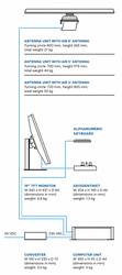
• A special cable for connecting the antenna to the central unit
• Available in the length you need

Marine radar: navigation and collision avoidance on the water
One of the fundamental functions of marine radar is to determine the bearing and distance of surrounding objects. Radar information can be used to monitor nearby vessels, coastlines, islands and other obstacles. For collision avoidance, EBL and VRM can be used, while ARPA functions can provide data related to the movement of surrounding vessels. This can include bearing, distance, CPA, meaning Closest Point of Approach, and TCPA, meaning Time to Closest Point of Approach.
How do marine radar and the radar antenna work?
Marine radar scans the area surrounding the vessel using a rotating radar antenna. The antenna transmits a microwave signal that is reflected by vessels and other obstacles and returns to the antenna. The system uses these reflections to generate the image displayed on the radar screen. Marine radar systems can use X band and S band technology. S band radar has different detection characteristics in sea clutter and rain, while X band can provide greater detail and accuracy in clear weather conditions.
Radar display, radar range and target tracking
The radar display presents the radar image generated from the area surrounding the vessel. Using the bearing and distance of a fixed and reliable radar object, the navigator can also use the information to determine the vessel's position. EBL and VRM, as well as ARPA, can be used to analyse target movement. Radar range can be adjusted by selecting the appropriate range scale.
Which settings support the use of marine radar?
Marine radar controls can include brightness and contrast as well as manual or automatic gain and tuning adjustment. Further settings can be used to reduce sea clutter and rain clutter and to minimise interference. Common controls also include range scale, bearing cursor, VRM and EBL.
- EBL can be used to determine bearing information.
- VRM provides a variable distance marker.
- Sea clutter and rain clutter controls are used to adjust radar presentation.
- Interference reduction is used to reduce interference.
Marine radar and integration with other navigation systems
Radar can also be used together with other marine instruments. Electronic GPS navigation charts or sonar information can be displayed on the radar screen. On commercial vessels, radar can operate as part of the navigation instrument system together with a chartplotter, sonar, marine radio, GNSS receiver and SART devices. Digital data buses allow information to be exchanged between individual devices.
What should be considered when using marine radar?
When interpreting radar information, measurement and operating errors must also be taken into account. Range or bearing errors may occur, and incorrect results can also be caused by improper use of own-vessel data. Radar therefore provides navigation information that must be used with appropriate settings and correct interpretation of the displayed data.
Advantages:
- Detection of other vessels and land-based obstacles.
- Provision of bearing and distance information.
- Usability in restricted visibility.
- Support for determining collision-avoidance data.
Limitations: the accuracy and interpretation of the radar image can be affected by measurement errors, incorrect settings and improper use of own-vessel data.
Summary: the role of marine radar in navigation
Marine radar is a navigation instrument used to monitor the surrounding environment, determine the position of vessels and obstacles, and assess collision risk. The radar antenna, radar display, range settings, EBL, VRM and ARPA can provide different levels of navigation information. Together with other marine instruments, radar can also form part of an integrated navigation system.
What are the most common questions about marine radar?
- What is marine radar used for?
It can be used to detect other vessels, coastlines and obstacles, measure bearing and distance, support navigation and assist collision avoidance. - Can radar be used in poor visibility?
Yes. It can be used to monitor the surrounding area in fog, adverse weather conditions and at night. - What do EBL and VRM mean?
EBL is used to determine bearing, while VRM provides a variable distance marker on the radar display. - Which other navigation devices can radar work with?
Radar can be integrated with chartplotters, sonar, marine radios, GNSS receivers and other navigation instruments.